Rattanak Kiri
RATTANAK KIRI
Rattanak Kiri is the mountainous northeastern frontier province of Cambodia that borders Laos to the north, Vietnam to the east,Mondul Kiri Province to the south, and Stung Treng Province to the west. It extends from the mountains of the Annamite Range in the north, across a plateau between the Tonle San and Tonle Srepok rivers. Famed for its stunning natural beauty and ethnic diversity, Rattanak Kiri is full of natural and cultural treasures just waiting to be discovered. Its capital is Banlung City.
Rattanak Kiri boasts some of the most striking landscapes the region has to offer and is home to several settlements of ethic hill tribes. Among the many picturesque natural sites are the crystal clear Yeak Laom volcanic lake, incredible fresh waterfalls, gem mines, and a dense rainformest teeming with exotic flora and fauna. In contrast to modern day opulence, this province remains largely untouched as the majority of the population in Rattanak Kiri is made up of ethnic minority groups living harmoniously with nature.
Most visitors to Rattanak Kiri choose to base themselves in Banlung City from where excursions can be arranged to visit the Khmer Loeu villages and an array of natural sites.
RATTANAK KIRI TOURIST ATTRACTIONS
Yeak Laom Lake
Yeak Laom Lake is located about 5 kilometers southeast of central Banlung. This beautiful lake is a crater formed after a volcanic eruption over 4000 years ago; the diameter of this lake is about 800 meters and it bears about 50 meters of clear water.
At one end, there are two wooden platforms for tourists to view the lake up close, but some people cannot resist a dip to feel
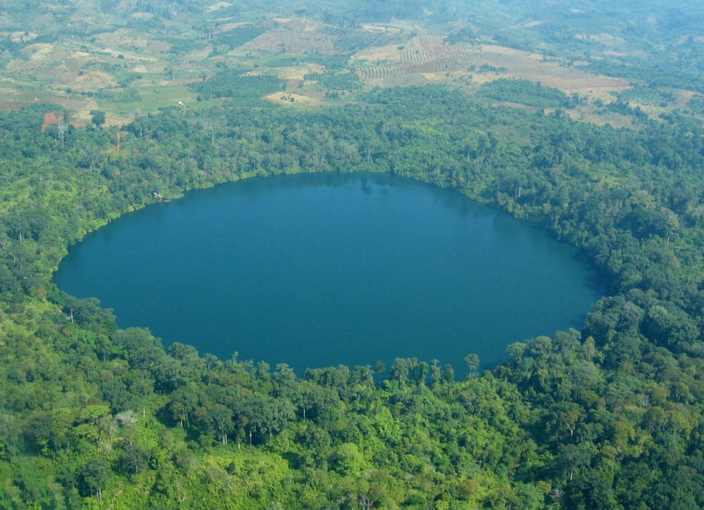 the warmth of the water for themselves.
A path surrounds the lake, providing a leisurely track for trekking. A walk around the lake takes around forty minutes. Midway along the track, at the western end of the lake, there is a small visitor center which exhibits and sells local handicrafts such as musical instruments, crossbows, baskets, scarves and handbags made from hand-woven cloth.
Wild pigs and rare birds including eagles can be seen around the lake and tourists may also spot rarely seen large brightly colored butterflies; some with wing spans of up to 20 centimeters.
The Cambodian term ‘ Yeak Laom ’, translated into English means ‘giants’ and ‘surroundings’. Thus, the legend of the lake, often recited by local raconteurs, goes as follows:
In ancient time, there was a very powerful giant king who had the most attractive daughter. Both her hair and body emitted a fragrant aroma so the giant king named her ‘Neang Sak Kra Oob’ which means ‘fragrant hair girl’. When she grew up, a strong, handsome man came to woo her. Their love for each other soon grew up strong but this lovely couple was afraid that the giant king would eventually discover their secret love so they both decided to flee into the deep forest.
Soon after, the giant king learned of his daughter’s situation and he was both deeply shocked and distresses. First he expressed pity for his daughter. Then he assembled a battalion of troops to search for his beloved daughter. His entire kingdom and the jungle were checked by his gigantic army of soldiers but they could find no sign of her even as they finally reached the thick forest where a pond is located today.
The giant king suspected that his daughter might be in the forest so he deployed his massive forces to secure the perimeter of the forest. Suddenly, he ordered all his troops to pull out of the forest and dig there surrounding ground very deeply to find his precious daughter. They all dug with vigor but the soldiers eventually became exhausted and their efforts were to no avail. Finally, the giant king reluctantly ordered all his troops to return to his kingdom.
The giant hold dug by the giant king’s troops, including the uprooting of trees, in an unsuccessful effort to find the King’s daughter, has left this deep pond in the Ratanak Kiri area. That is why the local people call this site “Yeak Laom Pond”.
But there is a slightly different version from that previously mentioned. This version declares that there was a giant commander who had tried to arrest the giant king’s daughter and separate her from her lover. When the troops of the commander surrounded the mountain where they were hiding, this lovely couple thought that there was no way to escape.
Because their true love, both of them decided to wish to disappear into the ground. They both started to pray to the spiritual power, Preah Eisey, and to all of the gods, ‘with your respectful magical powers protecting this area in perpetuity, please, we will sacrifice our live by making the sink down ’. Suddenly, the mountain area quickly sunk into the ground including the giant king’s daughter and her lover. This is why this plateau top has become a deep pond and is the reason the local people call this pond ‘Yeak Laom’.
Another ancient folktale claims that the story of the origin of this ‘Yeak Loam’ name is completely different and likely more believable. The recalls that ‘Yeak’ in the language of the ancient minority living there meant the ‘owner or the chief of the villagers’. The word ‘Loam’ was the name of the person who was a former chief of that area. So, there for the words ‘Yeak Laom’ is a respectful reminder of the sacred and spiritual nature of their ancient leader that used to rule the local minority people in happiness and harmony a long time ago.
Ethnic Minority Museum
Near the shore of the Yeak Laom lake there is a traditional wooden house built to preserve and display many kinds of traditional hill tribe textiles and tools such as musical instruments, farming tools, fishing gear and clothes.
Cha Ung Waterfall
The waters of the Cha Ung waterfall rise in the Phnom Svay Mountain close to Ban Lung town. The waterfall is 25m high and surrounded by various creepers and by climbing plants. The scene is very picturesque- the water spray generated by the water cascading off the vegetation creates its own rainbows in the sunlight.
Today there are new concrete stairs in place to ensure that visitors can easily access the bottom of the waterfall from the top of the hill. The waterfall has vendors selling foods, soft drinks, snacks and some local souvenirs.
Behind the waterfall is a large rocky cave from which visitors can gain a different perspective of the scenery through the water. At the base of the falls are natural scattered large boulders where trekkers can relax and take in the incredible views.
The waterfall is located in the Kreung hill tribe village of Cha Ung, Ou Chum district. To get there, travel two kilometers beyond Ban Lung town on the National Road No.78, then turn right and follow the trail for six kilometers.
Eisey Patamak Mountain
Visit the Eisey Patamak Pagoda on Phnom Svay, situated 2.5 kilometers from the town center of Banlung. A five meter long reclining Buddha rests peacefully in a hut adorned with paintings depicting the teachings of the Buddha. Be captivated by the spellbinding serenity of the surrounding countryside; enjoy some of the most gorgeous views across the green and verdant hills of Ratanakiri from here. The ambience here is one of peace and calm.
Kachanh Waterfall
Located in Kachanh Commune, Banlung District, the Kachanh Waterfall is 6 km from Banlung town.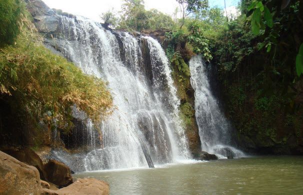 The waterfall is 12 meters in length, which flows endlessly along the Kantoeng Stream to the Sre Pork River in Lomphat District.
Among the stream and rubber plantation, the Kachanh Waterfall provides great scenery for tourists. The stream’s bottom can be accessed by a wooden stair having approximately 72 steps. On the side of the top of the waterfall, big trees branching out cast cool shadows over tourists for picnicking there.
Katieng Waterfall
Three kilometers from Ka Chanh waterfall is the 10 m high Katieng waterfall. The cascading falls are surrounding by trees that provides welcome shade to the visitors.
The falls are best viewed from below. At the base of the falls are naturally scattered large boulders that visitors can climb. Also available are elephants for scenic tours of the surrounding forest.
Unique Kreung handicrafts, souvenirs and other products are to be found here. These include the ‘back-strapped baskets’, natural fabrics, gourd vessels and gongs.
The waterfall is to be found in Katieng village, in Lbang I commune of Lum Phat district. Distance from Ban Lung town is around seven-kilometers.
Lumphat's Wildlife Harmony
Lumphat Wildlife Sanctuary is the part of Ratanak Kiri wildlife sanctuary. It has an area of 2,225 square kilometers, and charms tourists with its picturesque forests and tranquil surroundings. It’s also a haven for a wide range of wildlife, including some endangered species.
Lumphat Wildlife Sanctuary contains mountains, forests, and lowlands. It provides ideal shelter for large mammals such as elephants, bantengs, gaurs, tigers, and wild buffalos, as well as bears and smaller carnivores and primates.
The Forest has roughly a dozen large wild animal species. There are around a hundred bird species here, including waterfowl.
Besides providing shelter to a diverse range of wildlife, the Sanctuary is also home to more than 100 indigenous families, mostly from the Phnong minority. They make their living entirely from the park’s natural resource, utilizing natural resins, vines, rattans, herbal trees, and forest products.
Tourists wishing to visit Lumphat should contact the park rangers of Phnom Prik national park. They will guide them around the site. If visitors want to see more, they can camp here for up to one week.
Ou’Sinlair Waterfall or 7-level waterfall
Ou’Sinlair waterfall, located in Ratanak Kiri province, is an idyllic destination offering wonderful opportunities for eco-tourism. The area is covered by the emerald forest and surrounding mountains.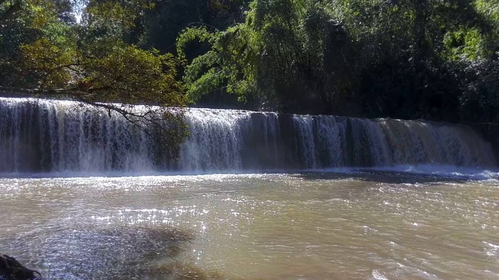
This waterfall has kept is secrets well hidden in the jungle until only recently; the road conditions have improved sufficiently to enable the adventurous to experience this wonder natural waterfall during the dry season.
O’Sean-lair waterfall is found in Lum Phat district, just 30km south-west of Banlung. There is no good road to the falls, and this prevents mainstream tourism. Visitors get there by truck or four wheels drive vehicles with an experienced driver at the helm. Driving speeds are slow along the small trail which snakes through the jungle and traverses several small rivers. The journey requires a full day and travelers must prepare pre-packaged meals and drinks, none are available on the trail or at the falls.
The cascade itself is a 7-level waterfall, picturesquely located in the middle of the preserved tropical jungle; sunlight barely penetrates some parts of the area.
There are 4 waterfalls in total on this watercourse. The Ou’Sinlair Falls are in the central part of the stream, with one cascade downstream and 2 more located about 3 hour walk upstream. At the central part of the cascade, the water falls 4 meter over a 30 meter span. This level is the most convenient place for trekkers to bath and take a swing in the clear nature waterfall which keeps temperatures cool.
The water flow during the dry season is moderate, making it suitable for swimming. During the monsoon season, the fast current, eddies and undertow make bathing hazardous.
Ou’Sinlair Waterfall is off the beaten track and a rewarding retreat in the jungle. One can only speculate how many more beautiful waterfalls lie hidden it the jungle awaiting discovery.
Se San River
The Se San River is one of the most important ecology systems amid the green forestry in the northeast region of Stung Treng and Ratanak Kiri provinces. The river is like shining diamonds and emeralds with white sand beaches while the clear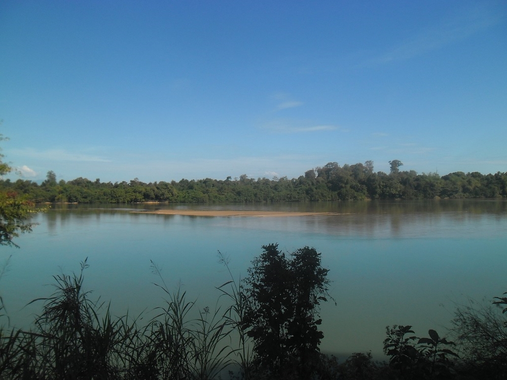 water along the river reflect the mountains and jungle even during the dry season.
Forty km. away from northern part of Banlung, the capital of Ratanak Kiri, the Se San river is an all season river flowing east to west with long, white sand beaches. Along the river, these numerous beaches have many spots for bathing, swimming and fishing where both local and international tourists can relax.
Cross over the Se San River by boat and you see the Veon Sai commune. That is the territory of several ethnic groups such as Khmer, Chinese, Kroeng, and Laotian, all living there for many generations. The Chinese follow their own Chinese traditional culture while the other ethic groups follow their own ancestral identities. All communicate in Chinese, Hill Tribe, and Laotian as well as well as the national language of Cambodia, Khmer. Most of them are farmers, fishermen and local traders.
Tat Tay Waterfall
The Tat Tay is a beautiful, natural water rapids. While the roads to the rapids are rough, it usually takes about 2 hours by motorbike from town. It is located along the Sre Pork River, in Lum Phat commune, Lum Phat district, Ratanak Kiri province.
A Tat Tay water rapid is a seasonal attraction, most visited from February to April. During this period, visitors like to come and enjoy the beautiful clear waters. In part of the area, there are mango plantations.
Veal Ram Plang
Veal Ram Plang means the Ram Plang field and is an attractive nature spot that is part of the territories of the legendary hill tribe communities living there. It is a mesa plateau area on top of a mountain in Ratanak Kiri province. On this field are grass and wild plants, which flower during the whole rainy season from May till January. Near the field is a small, clean river.
Veal Ram Plang got its name from the son of a hill tribe chief who lived in the surrounding area. According to legend, a long time ago Veal Ram Plang was the natural mountain playground for many of the local hill tribe children who used to come here to fly their kites and play.
Once day, a boy named Ram Plang, the son of the local hill tribe chief, came for his usual kite flying. When he was flying his kite, a strong wind came up and tore his kite away. It flew up and was caught on the top of the tallest Sra-lav tree (the Latin word for this tree is Vateria coincidences).
Ram Plang was unhappy about the fate of his beautiful kite so he decided to climb up the tree to get it back. Unfortunately, when he reached the top branch of Sra-lav where his kite was stuck, the branch broke and he fell to his death.
His friends reported the news to Ram Blang’s father and to the villagers. They all came to his traditional hill tribe merit ceremony funeral. Ram Plang’s body was kept there in a small tomb and his kite was put inside that tomb. Later on, his beautiful long kite became a river which still remains to this day.
The place and date of Ram Plang’s death is celebrated in a respectful ceremony by all of the hill tripe future generations.
Hill tribe people of the region came from all around to honor Ram Plang’s spirit. They brought many wine jars, food and fruit to this ceremony each year. The rice hull rubbish from the traditional hill wine was thrown away near Ram Plang’s tomb. This huge rice hull pile got bigger and bigger after many years of ceremonies until it became a small hill.
Virachey National Park
Picturesque natural forest, stunning mountains, plateaus, valleys, local ethnic communities and a diverse wildlife all await visitors at Virachey National Park.
Virachey National Park covers an area of 3, 325 square kilometers in Veun Sai and Taveng district of Ratanak Kiri province. It’sabout 60 km north of Banlung town in Ratanak Kiri province. The Virachey Park serves as the largest national park in Cambodia.
In Virachey National Park, there are thousand-year-old trees, prairies, a hundred bird species including the Create Hornbill and Red-collared Woodpecker, and other diverse wildlife species.
The vast forests, grasslands, mountains and valleys remain largely unexplored and undisturbed by human settlement and may still harbor new and undiscovered wildlife species.
They provided important habitats for tigers, elephants, wild cattle and a number of spectacular, globally threatened primate and bird species. The northeast of Cambodia has been the home to many indigenous hill tribe people for centuries and remains a center for cultural diversity in the region.
Indigenous Brau and Kavet people continue to depend on the natural resources of Virachey for their survival and several communities are now participating in the park’s ecotourism program. Virachey has a rich, albeit tragic, historical heritage through its association with the American Vietnam war, the legacy of which can still be readily observed along the infamous Ho Chi Minh Trail that traverse the park.
Virachey National Park was designated as an Asean Heritage Park in 2003 in recognition of its outstanding contribution to regional and international biodiversity conservation.
Admission fee is $10 for a tourist, the price including a guide. Community guesthouses are also available at $5 per night.